ページの先頭です。 メニューを飛ばして本文へ
現在地 トップページ > 組織でさがす > 総務部 > 危機管理課 > 洪水ハザードマップ

本文

洪水ハザードマップ

ページID:0016439 更新日:2025年4月28日更新 印刷ページ表示


洪水ハザードマップ

洪水ハザードマップの更新について

令和5年5月に市内中小河川(45河川)が洪水浸水想定区域に指定されたため、宇陀市ハザードマップ(洪水浸水想定区域)を更新しました。

市全体洪水ハザードマップ大判
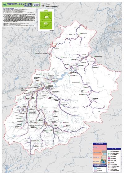
洪水ハザードマップ大判【市全体】 (PDFファイル:13.03MB)

洪水ハザードマップ大判【市北部】
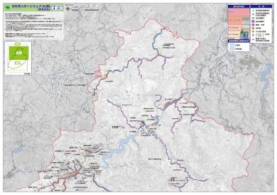
洪水ハザードマップ大判【市北部】 (PDFファイル:17.3MB)

洪水ハザードマップ大判【市南部】
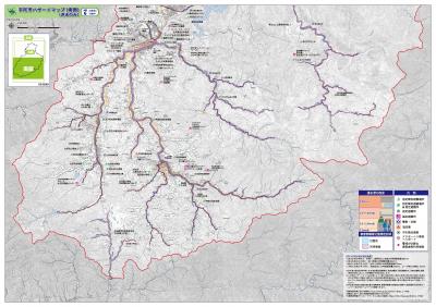
洪水ハザードマップ大判【市南部】 (PDFファイル:18.5MB)

中小河川洪水浸水想定区域の指定について

令和3年7月の水防法改正により、水位周知河川に加え、改正前には、洪水浸水想定区域の作成対象となっていなかった中小河川のうち、周辺に住宅などの防護対象のある河川が、洪水浸水想定区域の指定対象に追加されました。

令和5年度指定河川について

奈良県は、令和5年5月30日(奈良県告示第66号)に、宇陀市にかかる次の中小河川について、告示指定を行いました。

新規指定
淀川水系
地域 河川名(淀川水系)40河川
大宇陀

四郷川

1(PDFファイル:2.76MB)2 (PDFファイル:4.08MB)

守道川

1(PDFファイル:4.07MB)

片岡川

1 (PDFファイル:3.71MB)

中山川

1(PDFファイル:2.21MB)2 (PDFファイル:3.32MB)

麻生田川

1(PDFファイル:3.97MB)

芝生川

1(PDFファイル:2.51MB)2 (PDFファイル:3.76MB)

黒木川

1 (PDFファイル:2.58MB)2 (PDFファイル:3.84MB)

 
菟田野

宇賀志川

1 (PDFファイル:3.19MB)2 (PDFファイル:3.15MB)3 (PDFファイル:1.59MB)

佐倉川 

1(PDFファイル:2.57MB)2 (PDFファイル:3.8MB)

鈴谷川

1 (PDFファイル:2.74MB)2 (PDFファイル:4.08MB)

ほうい谷川

1 (PDFファイル:2.82MB)2 (PDFファイル:4.24MB)

榛原

天満川

1 (PDFファイル:2.59MB)2 (PDFファイル:3.82MB)

内牧川

1 (PDFファイル:3.18MB)2 (PDFファイル:3.17MB)3 (PDFファイル:1.6MB)

矢谷川

1 (PDFファイル:2.27MB) 、2 (PDFファイル:3.45MB)

八滝川

1 (PDFファイル:3.54MB) 


諸木野川

1(PDFファイル:2.18MB)2 (PDFファイル:3.26MB)

香酔川

1(PDFファイル:2.76MB)2 (PDFファイル:2.76MB)3 (PDFファイル:1.37MB)

池谷川

1 (PDFファイル:2.73MB)2 (PDFファイル:4.08MB)

町並川

1 (PDFファイル:2.83MB)2 (PDFファイル:2.8MB)3 (PDFファイル:1.36MB)

母里川

1 (PDFファイル:4.62MB)

笠間川

1 (PDFファイル:3.69MB)

   
室生

笠間川 

1(PDFファイル:3.53MB)2 (PDFファイル:2.61MB)3 (PDFファイル:3.42MB)
4 (PDFファイル:2.41MB)5 (PDFファイル:3.52MB)6 (PDFファイル:2.52MB)
7 (PDFファイル:3.56MB)8 (PDFファイル:2.56MB)9 (PDFファイル:3.51MB)
10 (PDFファイル:2.55MB)

川上川

1 (PDFファイル:3.66MB)

峠川

1 (PDFファイル:2.93MB)

滝の尾川

1 (PDFファイル:3.03MB)

阿清水川

1 (PDFファイル:3MB)2 (PDFファイル:2.97MB)3 (PDFファイル:1.48MB)

西谷川

1 (PDFファイル:2.03MB)2 (PDFファイル:1.98MB)3 (PDFファイル:1008KB)

滝谷川

1 (PDFファイル:3.31MB)2 (PDFファイル:3.3MB)3 (PDFファイル:1.65MB)

仮屋川

1 (PDFファイル:2.8MB)2 (PDFファイル:2.78MB)3 (PDFファイル:1.35MB)

高寺川

1 (PDFファイル:4.49MB)


北川

1(PDFファイル:2.31MB)2 (PDFファイル:2.32MB)3 (PDFファイル:1.14MB)

大野川

1(PDFファイル:3.37MB)2 (PDFファイル:3.32MB)3 (PDFファイル:1.68MB)

室生川

1 (PDFファイル:2.45MB)2 (PDFファイル:2.6MB)3 (PDFファイル:2.43MB)
4 (PDFファイル:2.57MB)5 (PDFファイル:2.41MB)6 (PDFファイル:2.57MB)
7 (PDFファイル:2.42MB)8 (PDFファイル:2.53MB)9 (PDFファイル:2.36MB)
10 (PDFファイル:2.51MB)

宇野川

1 (PDFファイル:2.79MB) (PDFファイル:2.8MB)3 (PDFファイル:1.4MB)

灰立川

1 (PDFファイル:2.83MB)2 (PDFファイル:2.78MB)3 (PDFファイル:1.4MB)

奥の谷川

1 (PDFファイル:2.48MB)2 (PDFファイル:2.46MB)3 (PDFファイル:1.24MB)

西の川

1 (PDFファイル:2.58MB)2 (PDFファイル:2.53MB)

石割川

1 (PDFファイル:2.54MB)2 (PDFファイル:2.5MB)3 (PDFファイル:1.24MB)

黒岩川

1 (PDFファイル:3.19MB)2 (PDFファイル:3.17MB)3 (PDFファイル:1.59MB)

宮城川

1 (PDFファイル:3.41MB)2 (PDFファイル:2.17MB)

 
大和川水系
地域 河川名(大和川水系)1河川
榛原

吉隠川

1 (PDFファイル:2.56MB)2 (PDFファイル:3.8MB)

紀の川水系
地域 河川名(紀の川水系)4河川
大宇陀

津風呂川

1 (PDFファイル:2.3MB)2 (PDFファイル:2.6MB)3 (PDFファイル:2.44MB)
4 (PDFファイル:2.67MB)5 (PDFファイル:2.37MB)6 (PDFファイル:2.6MB)
7 (PDFファイル:2.27MB)8 (PDFファイル:2.56MB)9 (PDFファイル:2.49MB)
10 (PDFファイル:2.75MB)


田原川

1 (PDFファイル:2.87MB)2 (PDFファイル:2.92MB)3 (PDFファイル:1.45MB)

栗野川

1(PDFファイル:2.95MB)2 (PDFファイル:2.97MB)3 (PDFファイル:1.42MB)

大蔵川

1(PDFファイル:2.77MB)2 (PDFファイル:2.77MB)3 (PDFファイル:1.37MB)

淀川水系・宇陀川、芳野川の洪水浸水想定区域図

河川名 区域図の種類 指定年月日・告示番号

淀川水系・宇陀川

洪水浸水想定区域(想定最大規模降雨) (PDFファイル:2.73MB)

洪水浸水想定区域(計画規模降雨) (PDFファイル:2.74MB)

浸水継続時間(想定最大規模降雨) (PDFファイル:2.74MB)

家屋倒壊等氾濫想定区域(氾濫流) (PDFファイル:2.73MB)

家屋倒壊等氾濫想定区域(河岸侵食) (PDFファイル:2.77MB)

平成31年3月26日
奈良県告示第491号

淀川水系・芳野川

洪水浸水想定区域(想定最大規模降雨) (PDFファイル:4.62MB)

洪水浸水想定区域(計画規模降雨) (PDFファイル:4.61MB)

浸水継続時間(想定最大規模降雨) (PDFファイル:4.64MB)

家屋倒壊等氾濫想定区域(氾濫流) (PDFファイル:4.66MB)

家屋倒壊等氾濫想定区域(河岸侵食) (PDFファイル:4.67MB)

令和2年3月27日
奈良県告示第494号

最新の情報は下記リンク先でご覧ください。

最新の公表された洪水浸水想定区域図は、奈良県ホームページでご覧いただけます。

Adobe Reader<外部リンク>
PDF形式のファイルをご覧いただく場合には、Adobe社が提供するAdobe Readerが必要です。
Adobe Readerをお持ちでない方は、バナーのリンク先からダウンロードしてください。(無料)